

Walking Tour Offers An Inside Look At Restoration Of The Childs River - CapeNews.net |
| Walking Tour Offers An Inside Look At Restoration Of The Childs River - CapeNews.net Posted: 25 Jul 2019 09:00 PM PDT 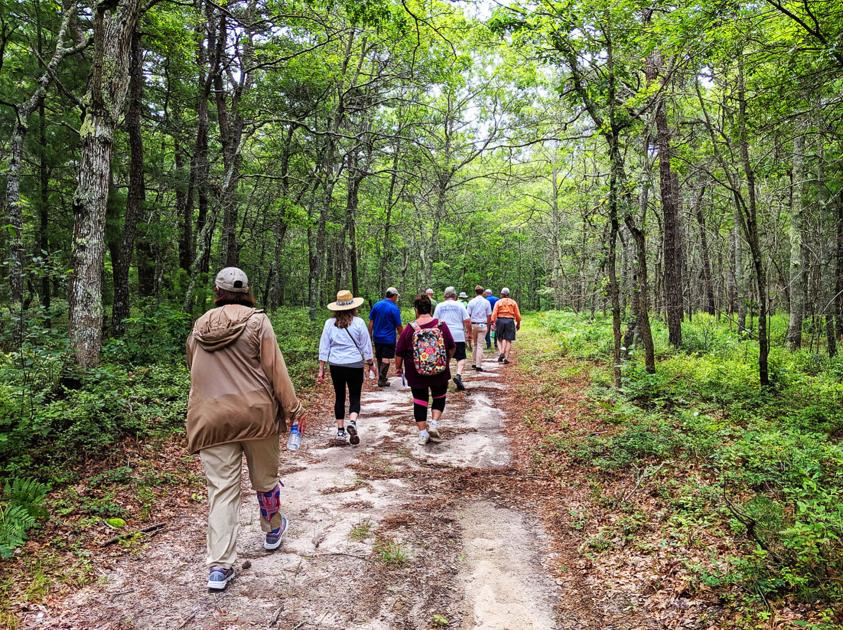 The Childs River restoration project tour started at the mouth of a dirt road, a narrow turnoff near a bend in Carriage Shop Road. Cars streaked by as Gary Anderson, treasurer of the Falmouth Rod & Gun Club, gestured to the body of water across the street. Childs River flows south through Mashpee and Falmouth, emptying out into Waquoit Bay and Nantucket Sound, he explained. Mr. Anderson pointed in the direction of out-of-sight blockages including an earthen berm, water control structures, and an undersized culvert. These structures contributed to the swelling of two parts of the river, transforming them into shallow ponds. The ponds warm quickly creating an inhospitable environment for the brook trout that used to swim in them, Mr. Anderson said. The 20-person group turned back toward the small dirt parking lot that suggested nothing of the acreage that lies beyond it. A one-mile trail circles conservation land that totals more than 100 acres, owned by the rod and gun club. Five minutes down the forested dirt path lined with "danger" signs (the land can be used for hunting) brought the group to a clearing. To the left of the clearing, Farley Bog stretched into the discernable distance. The rod and gun club purchased the bog, 12.5 acres, in 2017 for the purpose of restoring and conserving the land. To the right, a pile of cut trees were stacked twice the height of Mr. Anderson. "When a river meanders, when the streamflow hits the off bank, it begins to erode," Mr. Anderson explained. Pile-driving logs into the embankment will help decrease erosion, he said. Most of the logs came from the Frances A. Crane Wildlife Management Area. The group moved toward the bog. "This is what a cranberry bog looks like [when it] hasn't been farmed for five years," said Arthur D. (A.D.) Colburn III, a member of the board of directors for the rod and gun club. It looked less like a body of water and more like a pasture with shrubs. This was due to the fact that the bog had been somewhat overrun by invasive species like knotweed, Mr. Anderson said. The rod and gun club has removed invasive species by hand in certain areas of the site. "As we go along, by increasing the river or returning the river to its natural state, nature itself will get rid of those invasives," said James D. Anker, a member of the tour, who is involved with restoration efforts. The only visibly moving water in the bog can be found to the left and right of the path, near the entrance. A flood control device, used to flood cranberry bogs for harvesting, still manages the water flow. Stepping up to peer at the device, Mr. Colburn and Mr. Anderson warned the group to walk with caution. The area has "leaves of three," known as poison ivy. Mr. Colburn said the flood control device would be removed to facilitate restoration efforts. In order to restore the river and create an environment in which brook trout and other cold water species can spawn and migrate, other blockages will have to be removed as well. An existing culvert that runs beneath Carriage Shop Road is too narrow to allow passage of fish and other wildlife. A wider 4.5-by-9.5-foot culvert will be installed as part of the restoration effort. The club members believe they will have to wait until spring for work to begin on the replacement, Mr. Colburn said. The river technically flows down the middle of the bog, Mr. Colburn said. When the rod and gun club is finished with restoration of the site, the river will flow along the west side of the bog, rather than straight down the center. Altering the path of the river will take advantage of groundwater flow, a major source of water for the river, and shade from trees along the western bank will cool the habitat enough to allow successful spawning of trout. The former bog owner trucked in sand, coating the bed of the river with 18 to 24 inches of sand. "That's all going to be removed," Mr. Colburn said. Sand and silt are beneficial to cranberry production, but create a poor environment for trout to spawn, he added. Removing the sand should reveal a pebble bed which will facilitate growth of the trout population. A sand hill next to the bog will also be removed. Adjacent to the sand hill stands a wooden post called a "picture post." This restoration area was the first in Cape Cod to have these posts, Mr. Colburn said. Picture Post is a part of Digital Earth Watch, a program developed with support from NASA and run by the University of New Hampshire. The goal of the project, according to its website, is to turn phones into scientific tools. Users take photos of a site from particular angles using the wooden post and upload them to a database. The online database catalogs the photos to keep a record of changes to the site over time. On the ground, the process looks like one man turning slowly around a wooden post while balancing his phone on the post. It elicited a laugh from the group. Mr. Colburn walked to the other side of the path where a small stream connected the two ponds and ran beneath Carriage Shop Road. This was where members of the rod and gun club uncovered the largest brook trout they have found to date during electrofishing with MassWildlife, Mr. Anderson said. Mr. Colburn walked down toward the stream, stepping into the water with a pair of tall, patterned rain boots. He pulled out a brick-like device that he identified as a Hobo temperature data logger. The group received 10 from the University of Massachusetts School for Marine Science and Tech, he said. Mr. Colburn pressed a button on the tracker, connecting it to his phone. The phone screen displayed jagged lines, representing temperature changes over time. The tracker logs the temperature of the water it is submerged in every 15 minutes. The data is recorded and sent to Stephen Hurley at the Southeast District Office of MassWildlife and James Rassman at the Waquoit Bay National Estuarine Research Reserve. Data loggers along the river also track dissolved oxygen levels and water flow. A Woods Hole Research Center Rivers Observatory team samples water from nine locations along the river weekly to check water quality. "We're lucky to have them," Mr. Colburn said. "We've got a nice bank of data for people to review and interpret," Mr. Colburn added. One of the interpreters is Inter-Fluve, a river restoration company working on the design of restoration efforts for the Childs River. The group moved back toward the path. The dirt road arched to the right in a series of small inclines and declines. Forests surround the path. After a few minutes of walking, the group approached a second clearing. This space branched into two groves. Both areas were brightly lit pockets of green and yellow. These were the pollinator fields, Mr. Anderson explained, the secondary project the rod and gun club took on over the last year or two. It has dedicated five acres to plant species that would encourage pollinators to spawn and thrive. The rod and gun club received funding to use a large tractor from US Fish and Wildlife to grind stones and sticks. Its members then planted seeds. A long period of rainstorms ensured the success of the fields this year, Mr. Anderson said. The club had access to a greenhouse in Waquoit in the winter, Mr. Anderson said. This gave them the opportunity to raise a number of milkweed plants and asters for replanting in the pollinator fields. Anise hyssop, and prairie gayfeather dot the field as well. The leaders of the group lingered on milkweed, passing around colored informational sheets about monarch butterfly breeding. Monarchs exclusively lay eggs beneath the leaves of milkweed. They feed on the plant, whose toxins harm other species. The group stopped at three pollinator fields, each different in color and size. At the third stop, Mr. Colburn paused by a tangle of hoses and buckets. A well and generator provide irrigation to the fields. Eventually, the native perennials should be able to survive on their own, without irrigation, Mr. Colburn added. "If you embark on a project like that... to see how it's coming along has been very encouraging," Mr. Anderson said. After touring the last field, the group returned to the parking area and piled into cars to head back to the rod and gun club, on the other side of the river. Mr. Anderson thanked everyone for attending. The tour was conducted in partnership with the Town of Falmouth and the Association to Preserve Cape Cod. At the start of the tour, Mr. Anderson noted that the club would like to do a tour of the land from the Mashpee side at some point as part of its ongoing educational outreach. He added that although the land is privately owned by the club, it is open to the public for walking and hiking. |
| You are subscribed to email updates from "childs digital watch" - Google News. To stop receiving these emails, you may unsubscribe now. | Email delivery powered by Google |
| Google, 1600 Amphitheatre Parkway, Mountain View, CA 94043, United States | |


0 Yorumlar